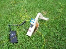
In addition to these antennas are electromagnetic armoured on all sides. Allow the penetration of radiation only on the ground. The depth is calculated by the software based on an equation of radar technique. The handles fully a person.
The machine consists of (transmitter and receiver), which is fix connected and in sync with the electronic brain. On the machine it is not necessary to exchange the antennas to become diaskopisi at other depths, because its operation is based on different physical principles, than e.g. happening in pulsed GPR. Above all it is possible with different settings in the software to optimize the detection engine in certain applications. In addition to these antennas are electromagnetic armoured on all sides. Allow the penetration of radiation only on the ground. The depth is calculated by the software based on an equation of radar technique. The handles fully a person.
APPLICATIONS:
Researches on restorations
Geotechnical construction diaskopiseis
Risks of landslides and mines.
Locating underground tunnels, trenches, etc.
Applications in archaeology and many surveys.
TECHNICAL CHARACTERISTICS:
GPR FMCW type.
Weight 11 kg.
Fix mounted antennas, impossible to replace.
Profile measurements via laptop applications.
Operating system: MS-Windows.
Imaging software: two-dimensional and mapping.
Dimensions: length 92-Width 32-height 40.
Transported by one person.
Lead acid battery 12V/18AH with car charger.
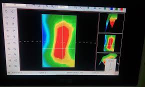
Example-reference for locating water and irrigation system and fields
Measurement location: Corinth (Greece) delves was the finding of a water supply and irrigation system fields at a depth of about 18 metres dating from the year 1900p. ch. And a marble slab under which stretched an underground cavity (tunnel).
Our spot was open a underground tunnel hint at a depth of about 5 metres. From the lodge she started an underground cavity (duct system) which was an upward trend.
The path of measurement designed to surface about 50 meters above the portico length of 25 meters.
In the measurement system of pipeline was detected in 18 meters depth as one could distinguish immediately on the screen of the laptop computer.
This result was very good for the originator of the measurement, however he wanted to see if the device of GPR KS 550 can anyone identify stable materials as well as underground anomalies.
For this reason in short time moved the controller with the car to another place where without much trouble and delay investigated the area.
The result was a plate at a depth of about 18 to 23 meters below which stretched an underground cavity (tunnel). The client was very pleased and investigates ended successfully. Our then recounted how he was going to a marble slab under which was an underground tunnel. The architect in Corinth (Greece)-he was the principal us-interested in the series as he wanted to use in underground exploratory tasks.


Post Tagged with : ground penetrating radar mobile | ground penetrating radar gold mining | lightweight ground penetrating radar | android table ground penetrating radar app | ground penetrating radar for rent | ground penetrating radar for gold reefs | ground penetrating radar for gold reefs | hand held ground penetrating radar | ground penetrating radar rental cost | android tablet ground penetrating radar program download | ground penetrating radar circuit diagram | ground penetrating radar circuit diagram | what is sir 3000 ground penetrating radar look like | portable ground penetrating radar system treasure hunting.